istanbul

istanbul

Impressions of Singapore

Singapore is a distant city-state in Southeast Asia, a shining success story that reflects the spirit of our age remarkably well while appearing, in another sense, strangely out of step with the modern world.

It reflects the spirit of the age because the mechanisms of capitalism operate here with extraordinary efficiency, producing a high level of prosperity and presenting themselves almost as an example to the rest of the system. Singapore has long ranked among the world’s wealthiest countries in terms of income per person.

Yet it also seems historically improbable. The age in which city-states occupied a central place in world affairs lies far behind us. Empires have disappeared, and even the nation-state which is the political model that replaced them is increasingly questioned. Against this background, the continued existence of a highly successful city-state in the twenty-first century is fascinating.

This cannot be explained satisfactorily by saying that foreign powers simply poured money into the country and created it from nothing. Singapore seems instead to demonstrate that even within a deeply imperfect world system, remarkably good results can follow when a society repeatedly makes the right decisions.

Let us begin with a very brief look at its history.

Singapore was a relatively minor settlement when Sir Stamford Raffles arrived in 1819 on behalf of the British East India Company and established a trading post. From that point onwards, it developed into an increasingly important British colonial port and soon became one of the leading centres of the regional rubber trade.

During the Second World War, Singapore was occupied by Japan. It returned to British control after the war, gained internal self-government in 1959 and joined the newly formed Federation of Malaysia in 1963.

The union did not last long. In 1965, following serious political disagreements, Singapore separated from Malaysia and became fully independent.

At that moment, Singapore was small, vulnerable and far from prosperous. It lacked natural resources and had a population divided among several ethnic and cultural communities. Yet through a combination of disciplined administration, strategic planning, foreign investment, international trade and some exceptionally bold political decisions, it developed within a remarkably short time into a prosperous society of several million people.

It followed a course that secured the support of the Western world while preserving considerable freedom to make its own choices. Not every decision was liberal, and not every method would be easily accepted elsewhere, but the state repeatedly placed its pieces on the right squares and avoided becoming merely a pawn in somebody else’s game.

Geographically, Singapore is an island lying immediately south of Malaysia. More precisely, it consists of one principal island and a collection of much smaller islands.

Its population is mainly Chinese, Malay and Indian. Chinese culture is the most visible, but Malay and Indian - particularly Tamil - traditions also maintain a strong presence.

Religious practices, languages and the routines of daily life coexist in a carefully managed multicultural society. These different traditions have not disappeared into one another; instead, they have been combined with a broadly international and Western-style urban life to produce a distinctive social mosaic.

Let us now begin exploring Singapore. The photograph below shows the central business district.

It is a sterile, modern and thoroughly global landscape. The impression is not entirely unlike Hong Kong, although Singapore has a character of its own.

For a broader view, let us raise our line of sight and look at the same district from another angle. In the foreground is Collyer Quay on the edge of Marina Bay, with the towers of the financial centre immediately behind it.

Turning slightly to the right, towards the east, we begin to understand the shape of the city more clearly. The districts extending inland from the coast and the older settlements beside the winding Singapore River appear in the photograph below.

When rapid economic development takes place within a severely limited area, vertical growth becomes almost inevitable. Singapore has certainly received its share of that development, and high-rise buildings dominate the central districts.

At this point, let us return briefly to the early years of the settlement established by Raffles and look at Singapore in the nineteenth century.

I photographed the following painting in a gallery at the National Museum of Singapore.

As you can see, our city-state has travelled a considerable distance. What began as a strategically placed colonial port has become one of the world’s most advanced economic centres.

Before going down into the streets, we should say something about the climate.

Singapore lies very close to the Equator and has a fully tropical climate. The air is hot and extremely humid. This continues throughout the year: there is no autumn, winter or spring in the conventional sense. There is simply summer, followed by more summer.

Day and night remain close to twelve hours each throughout the year. Sudden tropical downpours are common, and they may be followed almost immediately by fierce sunshine.

Singapore is comparatively sheltered from some of the region’s most destructive natural forces. It lies outside the principal typhoon belt and does not sit directly on a major earthquake fault, although storms, flooding and the effects of distant seismic activity are naturally not impossible.

We can now leave the panoramic views and descend to street level.

Our first photograph was taken from Esplanade Bridge, which can also be seen in some of the earlier photographs.

The bridge crosses the mouth of the Singapore River and connects the financial district with the eastern side of the city centre.

As you can see, the sense of sterility visible from a distance continues at street level. Singapore has a formidable reputation for cleanliness, and it is not undeserved.

The shell-like building towards the right of the photograph is the Esplanade concert hall. The design is often compared with a durian, the large tropical fruit whose odour inspires strong and sharply divided opinions.

While walking through the city centre, one naturally looks for scenes that appear characteristically Singaporean. Yet Singapore is so international that the local and the global seem to have become thoroughly entangled.

Consider the photograph below.

Street names such as Queen Street and New Bridge Road may initially seem unexpected in Southeast Asia. The woman passing on her bicycle does not offer an obviously exotic image either. But this is what it means to be a genuinely international city.

I mentioned earlier that Chinese, Malay and Tamil traditions coexist within a largely Western-style urban structure. English is the principal working language and one of the country’s official languages, but the local cultures continue to make themselves clearly visible.

Before exploring them, let us pass the National Museum of Singapore.

The painting of historical Singapore shown earlier is kept here. The museum is genuinely worth visiting, particularly because it demonstrates how comfortably Singapore presents its complicated history. The country displays both its indigenous and imported past without obvious embarrassment. Colonialism, migration, war, commerce and independence are all presented as parts of the long and sometimes uncomfortable journey towards the present.

The museum occupies an elegant colonial building that has been carefully restored. Anyone visiting Singapore should make time for it.

A similar architectural touch can be found in the former Hill Street Police Station, now used as a government building.

The same historical atmosphere appears in the calm of Emerald Hill, where old houses stand in striking contrast with the enormous shopping centres immediately behind them.

I find this contradictory coexistence appealing: an elegant historical presence on one side, and on the other a chaotic, shameless and overpowering expression of the present.

As one moves around Singapore, the different cultures from which the city was formed gradually become distinguishable.

Little India is probably the most colourful and apparently disorderly of Singapore’s central districts. The word “disorderly,” of course, must be understood according to Singaporean standards. This is a country where the import and commercial sale of ordinary chewing gum are tightly restricted, even though chewing it is not in itself generally prohibited.

Little India is filled with brightly coloured shops, restaurants, markets and temples.

The small businesses below remind me of the old commercial streets found in many Mediterranean and Middle Eastern cities: hardware shops, grocers, computer dealers, fruit sellers, exchange bureaux and almost everything else one might require, all crowded together.

The city’s Malay and Muslim heritage is especially visible around Kampong Glam, not far from Little India.

The most prominent building there is Sultan Mosque, with its large golden dome.

Let us now continue towards Chinatown.

Chinatown lies immediately beside the financial district, on the western side of the city centre. Since the majority of Singapore’s population is ethnically Chinese, Chinese culture is not confined to this district, but here it becomes especially concentrated and visible.

The photograph below shows South Bridge Road in the centre of Chinatown. The handsome red building on the left is the Buddha Tooth Relic Temple.

Upon entering, one encounters an abundance of Buddha figures, colour, gold and religious imagery.

The temple makes it immediately clear that Buddhist forms of worship and sacred architecture belong to a tradition very different from those most familiar in Europe and western world.

Here is one detail from the interior.

Another temple in Chinatown, less imposing but perhaps warmer in atmosphere, is Thian Hock Keng.

The contrast between its small courtyard and the high-rise buildings behind it creates an interesting image. It seems almost to symbolise the uneasy coexistence of material and spiritual values.

Since Chinatown stands immediately beside the financial district, the towers of institutions that command money quite literally overshadow the beautiful temple.

As our brief tour of Singapore’s streets comes to an end, we should turn to food.

It is easy to find excellent examples of both local and international cuisine. The general standard of eating and drinking is genuinely high.

Singapore is an expensive city, and restaurant prices often reflect that fact. Yet the people of Singapore fill bars and restaurants not only on weekend evenings but also after work during the week.

The photograph below shows the waterfront of the city centre at night. Most of the buildings along the river contain cafés, bars or restaurants, including the red-roofed building.

Seafood is particularly good. Even writing about it is enough to remind me of the flavours.

Since we have moved into the night, it would be impossible to omit Marina Bay Sands.

The building consists of three 56-storey towers supporting an enormous platform shaped rather like a ship. On the roof are swimming pools, restaurants, bars and observation areas.

Whether it is beautiful is open to argument. That it is impressive cannot seriously be denied.

The unusual lotus-shaped building on the left is the ArtScience Museum. The vast complex beneath the three towers is, naturally, a shopping centre and, in addition, a casino.

I also photographed the enormous rooftop platform from the side. I shall leave the architectural judgment to you.

Now that we are already looking from above, let us turn towards the sea.

Singapore developed around the point where the Singapore River reaches the coast. Today, the meeting place of river, bay and sea offers a landscape that is largely the product of human intervention.

A vast area of reclaimed land has been transformed into Gardens by the Bay, an ambitious and genuinely impressive group of botanical gardens.

The two shell-shaped glass buildings on the left contain enormous climate-controlled conservatories.

Moving beyond the mouth of the river, one sees the extraordinary density of maritime traffic surrounding Singapore.

This offers a fairly strong clue to at least one source of the country’s prosperity. Singapore occupies one of the most strategically important positions in world shipping, and the sea around it is filled with cargo vessels and tankers waiting, loading, unloading or passing through.

Returning to ground level and travelling further inland along the river, one repeatedly encounters the close relationship between old and new.

By now, having formed some impression of Singapore, you may decide for yourself what this coexistence means.

Two further places should be mentioned before concluding.

The first and perhaps one of Singapore’s most memorable experiences is the Night Safari, situated in a wildlife park about twenty kilometres north of the city centre.

I have no photographs because the visit takes place in darkness. Electric vehicles carry visitors through carefully designed environments in which nocturnal animals can be observed under very low lighting.

The experience creates the sensation of entering the animals’ world rather than bringing them into ours. I would not recommend leaving Singapore without seeing it.

The second is Sentosa, an island immediately south of the main island.

Almost the whole of Sentosa has been developed into an enormous leisure and entertainment complex. It contains hotels, beaches, water attractions, aquariums, cable cars, Universal Studios and numerous other diversions.

It is, in effect, a gigantic amusement park. A visitor could remain there for several days, travelling by monorail and cable car, without feeling much need to enter Singapore proper.

Since I had not spent long hours on an aircraft in order to visit an amusement park, I did not explore Sentosa in great detail.

That, then, is the brief story of this remarkable city-state as I saw it.

Singapore left me with very pleasant memories but also with a question that remained after the journey: how did such a small, vulnerable and historically improbable country manage to make so many things work?

Impressions of Malta

This time, I would like to write about Malta, a small island country lying almost at the centre of the Mediterranean.

Malta is an archipelago, although most of its population lives on the two main islands, Malta and Gozo. One theory connects its name with the Greek word for honey, while another traces it to an ancient Phoenician word associated with a harbour or refuge. Whatever its linguistic origins, the country presents the visitor with a distinctive mixture of Italian, British and Arab influences. It is a remarkably attractive combination.

Its long relationship with nearby Italy, the cultural legacy of the Arabs who once ruled the islands, and the traditions of Britain—from which Malta gained independence in 1964—have become intertwined to form an unusual synthesis.

Let us begin with everyday life. Traffic moves on the left, one of the most visible remains of British rule. English is spoken almost everywhere, while Maltese is the other official language. Maltese is particularly interesting: it is a Semitic language descended largely from the Arabic once spoken in Sicily and Malta, but it is written in the Latin alphabet, with several additional letters of its own.

Let us look at the first photograph: a panorama from the waterfront of Valletta, the capital. Historic buildings and marinas lie beneath the old guns that once guarded the harbour. Directly opposite stands Fort Saint Angelo.

This photograph, in fact, offers a good summary of Valletta and its surroundings.

There is something slightly confusing about Valletta. The walled city itself is no larger than a compact district. The continuous urban settlement around it makes the capital appear much larger, but administratively many of the surrounding streets and waterfronts belong to neighbouring towns.

For that reason, the photograph above does not actually show Valletta itself: I was standing in Valletta when I took it. Still, there is no need to become too preoccupied with administrative geography.

A brief look at Malta’s past reveals periods of rule by the Phoenicians, Romans, Arabs, the Crown of Aragon, the Knights of Saint John, the French and the British. It is, in other words, a very colourful history, and every period has left something behind.

One especially interesting feature is the influence of the Ottoman Empire, even though the Ottomans never succeeded in conquering or governing the islands.

Before returning to history, let us look at a more peaceful contemporary scene: Vittoriosa Marina at sunset, with the basilica of Senglea rising above it.

After Sultan Suleiman the Magnificent captured Rhodes in 1522, he allowed the Knights of Saint John to leave the island. The knights, successors to the medieval Hospitaller order, eventually settled in Malta under their Grand Master and began a long period of rule there.

In 1565, a large Ottoman fleet arrived off Malta, carrying the forces sent to capture the island. The siege was fiercely fought but ultimately failed. The celebrated Ottoman commander Turgut Reis was mortally wounded during the fighting.

Convinced that the Ottomans would inevitably return, the Maltese and the knights began preparing for another, even larger attack. They strengthened their fortifications, raised new walls and constructed a new capital named after the Grand Master Jean Parisot de Valette.

For generations, the expected return of the Ottomans remained almost legendary in the collective imagination of the islanders.

But they never returned.

Let us now walk through the streets of Valletta, the city created by the knights.

Valletta has an architecture of its own. Buildings made from the island’s pale local limestone are enlivened by enclosed wooden balconies. The following photograph shows a typical Valletta building.

This architectural language appears everywhere. The wooden balconies may be green, red or another strong colour, but they are almost always painted in vivid tones.

Daily life seems as lively and informal as the architecture itself. We are, after all, in the Mediterranean. A cold and excessively formal manner would hardly suit the surroundings.

The café below—or perhaps it would be more accurate to call it a traditional neighbourhood coffee house—expresses this character particularly well. It seems arranged for the people who live there rather than for visitors, and its local atmosphere survives intact.

The most imposing religious building in Valletta is naturally Saint John’s Co-Cathedral, situated on one of the city’s principal streets.

It is called a co-cathedral because it shares the function of the bishop’s seat with another cathedral. To avoid turning this into a discussion of ecclesiastical administration, I shall simply refer to it as the cathedral from now on.

Built by the knights in the sixteenth century, the cathedral has a comparatively restrained exterior.

Here is one detail.

The interior was apparently rather plain when the building was first completed. Later, the knights seem to have decided that such modesty was unnecessary and decorated it with considerable enthusiasm.

The result is impressive, although certainly not understated.

One of Caravaggio’s most famous paintings, The Beheading of Saint John the Baptist, is kept inside the cathedral. Photography was not permitted, so I cannot show it here.

When evening falls, the attraction of the waterfront becomes more apparent. While walking slowly along the shore in the pleasant weather, I saw the basilica of Senglea once again and could not resist taking another photograph.

We have now seen something of Valletta and its immediate surroundings. What else is there on the island?

About forty minutes from Valletta lies the fishing village of Marsaxlokk. It is one of the best places to see Malta’s brightly painted traditional fishing boats.

The waterfront and its boats are below.

The village square is shaped by the church and the cafés around it. As elsewhere on the island, pale limestone buildings dominate the scene.

A practical note about travelling around Malta: during my visit, an extensive public bus network covered almost the entire island. The buses were inexpensive and reached nearly every place a visitor might wish to see.

Hiring a car was also possible, of course, although driving on the left might discourage those who are not accustomed to it. Given the reach of the bus system, another form of transport was hardly necessary for most journeys.

Mdina, situated near the centre of the island, is another place that should not be missed.

The name Mdina derives from the Arabic word madina, meaning “city.” Just outside it lies the town of Rabat—another name of unmistakably Arabic origin. The influence I mentioned earlier could hardly announce itself more clearly.

Let us enter the magnificent walled city of Mdina.

Mdina’s history reaches back to the Phoenicians. During the Arab period, from the ninth century onwards, the settlement was reshaped and fortified in a form that strongly influenced the town we see today.

The knights later added buildings reflecting their own traditions and Christian culture, but they did so without destroying the architectural harmony inherited from earlier centuries.

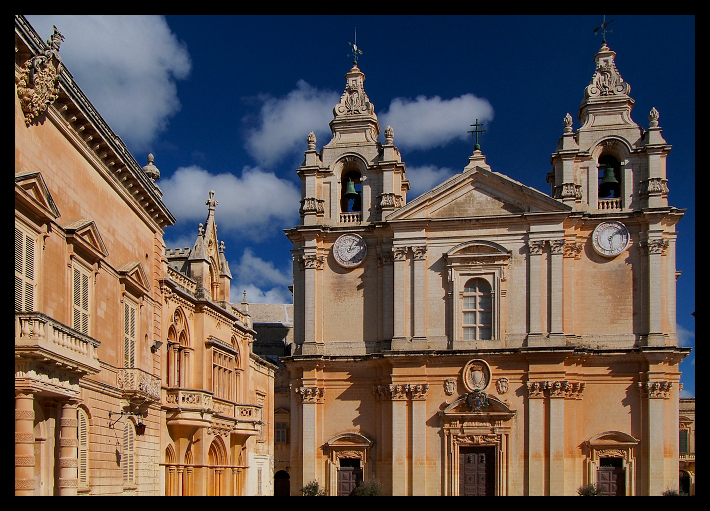
Here is Saint Paul’s Cathedral.

Notice the stonework.

Mdina is known as the Silent City, and the name is well deserved. Its atmosphere is exceptionally calm.

While walking through its stone streets, one sees signs reminding visitors that Mdina is not merely a historic monument but a living town, and asking them not to disturb its residents with unnecessary noise.

The signs appear to be effective. Without them—or without the few people who still live behind these old walls—one might easily imagine oneself wandering through a film set.

The street above presents a typical Mdina scene: partly medieval, partly Arab and Middle Eastern, and unmistakably Mediterranean.

It is difficult not to be affected by the atmosphere while walking through these streets.

Here is another view from Mdina. Horse-drawn carriages move along what pass for its broader avenues, while the narrower streets belong mainly to pedestrians and bicycles.

Only the cars of local residents are permitted to enter the town. All other “modern” vehicles must remain outside the gates.

Returning to the coast gives us an opportunity to see a more contemporary Malta.

Saint Julian’s, north of Valletta, represents the modern face of the island. Familiar apartment buildings and commercial developments extend for kilometres along the shore.

The district contains not only holiday accommodation but also much of Malta’s business activity, particularly in finance and banking.

Even at the time of my visit, the inflow of foreign capital was clearly visible. Malta had managed to establish itself as an international financial centre while remaining within the regulatory framework of the European Union. The expensive cars on the roads offered their own less scientific evidence of economic prosperity.

At the far end of Saint Julian’s, the Portomaso marina complex presents its vision of an affluent modern lifestyle without excessive modesty.

During my visit, hotels were not especially expensive and could even be considered reasonably priced by the standards of popular Mediterranean destinations.

Eating and drinking, however, were among the genuine pleasures of the journey. The quality of the predominantly Mediterranean and Italian-influenced cuisine was consistently high, and restaurant presentation was unusually careful.

Malta proved to be a surprisingly rewarding destination for food. Restaurants served local wines, but many also offered a broad selection of French wines at very reasonable prices.

When our aircraft left Malta, it made a brief turn over the island. Looking down, I noticed the Rotunda of Mosta and pressed the shutter.

The church is famous for its enormous unsupported dome, one of the largest of its kind in Europe—a remarkable structure to find in a relatively small town on a small Mediterranean island.

Seen from above, Mosta and its Rotunda resemble a landscape from the Middle East or North Africa more than the conventional image of a European town.

I left Malta pleased to have experienced this beautiful island, shaped by so many histories and cultures at the centre of the Mediterranean.

How Far Away Is The Horizon?

While pursuing attractive landscape photographs, I have taken many pictures that include the horizon. From time to time, a question occurred to me: how far away is that line I see?

For example, in the photograph below which I took while sailing off the island of Samos, what is the distance between me and the horizon?

At first, this may seem like a question that is almost impossible to answer. With a little thought, however, it turns out to be quite straightforward.

Since this blog attempts to reflect the beauty contained within the area I can see, I decided to calculate that distance, in other words, the radius of my visible world.

And it can be done rather simply.

The moment mathematics enters the discussion, many people immediately turn their eyes elsewhere. Still, with a little patience, you can see how the calculation works.

Consider the graphical masterpiece I produced below. The blue circle represents the Earth. I am standing at sea level, looking towards the horizon.

Let us assume that the Earth is perfectly spherical and that its radius is 6,370 kilometres, approximately its value at the Equator. In other words:

r = 6,370,000 metres

My height is:

h = 1.78 metres

What we want to find is the distance to the horizon, represented by u.

Since the diagram contains a right-angled triangle, we can use the famous theorem of Pythagoras: the sum of the squares of the two shorter sides is equal to the square of the hypotenuse.

In this case, the hypotenuse is the radius of the Earth plus my height.

(r + h)2 = u2 + r2

Expanding the expression gives:

r2 + 2rh + h2 = u2 + r2

After cancelling the terms that appear on both sides:

2rh + h2 = u2

Since we are interested not in the square of u, but in u itself, we take the square root:

u = √(2rh + h2)

When the values of r and h are placed into the formula, the result is:

u = 4,672 metres, or approximately 4.67 kilometres.

So, when standing at sea level on a clear day and looking towards the horizon, the visible limit lies slightly less than five kilometres away.

It was simply something I had wondered about, so I thought I would share it.

Update:

Increasing the height of the observation point above sea level greatly extends the distance we can see.

When I took the photograph below, the aircraft was flying at an altitude of 10,600 metres.

If we disregard the line of clouds obstructing the view and enter 10.6 kilometres as the viewing height in the same formula, the distance to the horizon is approximately 365 kilometres.

So, if you wish to see farther, it genuinely helps to rise a little higher.

Impressions from the Bordeaux Wine Region

Some cities are so closely associated with one particular thing that their names eventually become almost synonymous with it. Bordeaux is one of them. Yet the city itself is only part of the story. Surrounding it is one of the world’s best-known wine regions: a vast landscape of vineyards, small villages and producers whose wines range from modest everyday bottles to vintages costing thousands of euros.

I spent a week travelling through the region. These are some of the impressions that remained with me.

Bordeaux lies in southwestern France, about 600 kilometres from Paris and not far from the Atlantic coast. The city stands on the River Garonne, in the historic region of Aquitaine. The climate resembles that of the Mediterranean in some respects, though with one significant difference: rain is by no means unusual in summer.

Bordeaux has been an important settlement since Roman times, and grapes have been cultivated here for almost two thousand years. Today the region produces more than 900 million bottles of wine annually, a quantity rather difficult to imagine.

The range is enormous. There are inexpensive table wines, respectable bottles for ordinary consumption and wines that cost a small fortune. Vineyards extend in every direction, surrounding the towns and villages scattered across the countryside.

The most famous of these and probably the largest is Saint-Émilion, a medieval town about 30 kilometres east of Bordeaux. It is also listed as a UNESCO World Heritage Site. For anyone with time to visit only one place in the wine country, Saint-Émilion would be my choice. It appears not to have changed greatly in centuries.

Saint-Émilion is a town of stone buildings, narrow and often steep streets, and vineyards reaching almost to its outer walls. The main square is filled with cafés serving a constant flow of visitors from all over the world.

One might imagine that in a place so entirely devoted to wine, drunken people would be wandering through the streets at all hours. Nothing could be further from the truth. Here, wine is not primarily a means of becoming drunk. It belongs to a serious and deeply rooted culture of appreciation.

I took the following photograph of a wine shop in Saint-Émilion while standing just outside its door.

And now to the essential subject: the grapes.

Many varieties are grown in Bordeaux, but Merlot is the most widespread. Most producers do not make their wines from a single grape variety; instead, they blend several varieties in different proportions.

On the labels of more distinguished Bordeaux wines, the grape varieties are rarely given much prominence. What matters is the identity and style of the producer. Each château has its own blend, and the proportions may change from one vintage to another.

Less expensive wines are more likely to emphasise the grape variety. The more serious bottles present the producer, the château and the village. One should therefore not expect to find the word “Merlot” printed in large letters on the front of an important Bordeaux wine.

Besides Saint-Émilion, the best-known names include Saint-Estèphe, Pomerol, Margaux and Pauillac.

Immediately after leaving Saint-Émilion, the landscape begins to look like this.

And it continues in much the same way: vineyards everywhere. Thousands of producers transform each year’s harvest into hundreds of millions of bottles.

In recent years, competition from less expensive wines produced elsewhere in the world has made life more difficult for some local producers. The most prestigious wines, however, continue to sell extremely well, ensuring that at least some château owners remain quite content.

And this is where it all begins: a bunch of Merlot grapes still hanging on the vine.

From Saint-Émilion, we continue north towards Pomerol, another village whose wines can reach astonishing prices simply because the demand for them is so great.

As one approaches, there is a growing suspicion that the village will be very small. The suspicion proves correct. Pomerol has a population of only about 600 and does not even possess what one could properly call a village square.

This is the road into Pomerol.

Life here appears quiet and slow. It is difficult to believe that wines produced in such a small and unassuming place are sold throughout the world.

Like the other villages of the region, Pomerol is surrounded by vineyards belonging to estates known as châteaux. The term reflects older traditions of land ownership; many estates once included a large residence or an imposing winery building. Some still resemble castles. Others require a little more imagination, whatever their names may suggest.

Here is one near Pomerol.

Further north lies Margaux, another celebrated name in the world of wine. After driving for kilometres through vineyards, one arrives at yet another surprisingly small village.

Compared with Pomerol, Margaux almost seems substantial. It has around 1,500 inhabitants, a small square and several shops.

Welcome to Margaux.

It is difficult to determine where the village ends and the vineyards begin. The vines reach the streets and surround even the church and cemetery.

A small warning: picking grapes from the vineyards is not appreciated. This did not entirely prevent us from discreetly tasting one or two when nobody appeared to be watching.

Beyond the last houses, there are once again endless rows of vines, interrupted only by the occasional château.

Some of them genuinely do resemble castles.

One question naturally occurred to me: how can such an immense area possibly be harvested?

Most of the grapes are collected mechanically. It would be nearly impossible to do otherwise. The most valuable grapes, however, are still picked by hand, and during the harvest it is common to see workers moving through the vineyards with baskets.

The harvesting machines are interesting in themselves. They are large vehicles, not unlike combine harvesters, designed to travel between the rows and remove the grapes with as little damage as possible.

From a distance, the process looks like this.

Back on the road.

A journey through the Bordeaux wine region would be incomplete without Pauillac. Three of the five estates awarded the highest rank in the famous 1855 classification are situated here. Tasting wines at the level of Premier Grand Cru Classé is not an inexpensive activity.

Pauillac is as modest in appearance as the other villages, although it has a population of around 5,000 and even something resembling a main street.

Here it is.

The main street cannot be described as busy, although one is told that several cars may appear towards the end of the working day.

The village stands beside the Gironde estuary, its main street running parallel to the water. Behind it is a network of narrow streets, most of which look remarkably similar. There is not a great deal more to see.

That judgment may be slightly unfair. Pauillac does possess one memorable building: an old cinema that seems to have survived unchanged from the 1960s.

The sight of it made me wonder whether such places still existed. It reminded me of the cinema in Giuseppe Tornatore's movie Cinema Paradiso. Appropriately enough, this one is called Cinema Eden.

Beside it stands the village’s only shop selling local products. Entering it immediately alters one’s impression of Pauillac. Bottles priced at €700 or €800 sit quietly on the shelves.

The village may be simple. Its wines certainly are not.

Since few visitors are prepared to purchase bottles at such prices, some of these wines can be tasted by the glass. It should be added that this is not particularly cheap either.

Back on the road once more.

Having travelled through the wine country, it is finally time to visit Bordeaux itself.

With a population of about 250,000, Bordeaux is one of France’s larger cities. It has preserved much of its historic architecture while remaining lively and youthful.

The Romans developed Bordeaux as a port, and the city enjoyed a period of great prosperity during the eighteenth century. Its fortunes declined in the early twentieth century, but substantial investment in recent decades has transformed and revitalised it.

Bordeaux is especially impressive when seen from the banks of the Garonne.

The old warehouses and commercial buildings along the river have been restored and now contribute greatly to the character of the city.

There is no shortage of places to eat and drink, and social life is surprisingly active for a city of this size. Bordeaux also has a substantial cultural life and considerably more to offer than its worldwide association with wine might suggest.

The Grand Théâtre is one example.

I had only one afternoon to spend in Bordeaux, but it was enough to form a first impression. The main purpose of the journey, after all, had been to explore the surrounding wine region.

Before concluding, I should also mention where we stayed.

Throughout the trip, we stayed at La Maison Laurencine, a country house about 12 kilometres from Saint-Émilion and surrounded by vineyards. It had only four guest rooms, and the owners lived in the house themselves.

There are many places of this kind in the region. Ours was immaculately clean, carefully furnished and run by genuinely hospitable hosts. In spite of all this, the price was remarkably reasonable.

Here it is.

These, then, are my impressions of a region that takes the transformation of grapes into wine extremely seriously.

And perhaps rightly so. Wine has accompanied human civilisation for a very long time.